| Find Louisiana State Museum on Facebook |
 | Find Louisiana State Museum on Twitter |
| 2016 Sunset Report |
| OLG & DCRT Strategic Plan 2020-21 through 2024-25 |

- Quality - Louisiana State Library
85% of the users of the State Library indicated that the State Library's services and resources was a good value for the State.Source: The Impact of the Louisiana Department of Culture, Recreation and Tourism on Louisiana's Economy and Quality of Life for Louisiana's Citizens - June 2006
- Louisiana's deep water ports
Did you know that Louisiana's five deep water ports handle more than 457 million tons of U.S. waterborne commerce a year? - Quality - Louisiana State Library
85% of the users of the State Library indicated that the State Library's services and resources was a good value for the State.Source: The Impact of the Louisiana Department of Culture, Recreation and Tourism on Louisiana's Economy and Quality of Life for Louisiana's Citizens - June 2006
- Atchafalaya Heritage Area
The Atchafalaya Heritage Area has been designated by Congress as a National Heritage Area.
- Impact - DCRT Returns Investment Dollars to Louisiana
For every state tax dollar spent by the Department of Culture, Recreation and Tourism, $5.86 is returned to the State Treasury and citizens of Louisiana.Source: The Impact of the Louisiana Department of Culture, Recreation and Tourism on Louisiana's Economy and Quality of Life for Louisiana's Citizens - June 2006
- Impact - Louisiana Office of Tourism Tops Returns on Investment
$13.90 is the return on investment for every dollar spent by the Office of Tourism. Over 175,000 people were directly employed by the Louisiana travel and tourism industry in 2004. In terms of production, $5.9 billion (3.8%) of Louisiana's Gross State Product was directly attributable to expenditures by visitors to LouisianaSource: The Impact of the Louisiana Department of Culture, Recreation and Tourism on Louisiana's Economy and Quality of Life for Louisiana's Citizens - June 2006
- Impact - Supporting the Louisiana Arts
Every dollar in state support for the Arts leverages $7 in earned and contributed revenue. Louisiana's cultural enterprises provide nearly 144,000 jobs for Louisiana citizens, accounting for 7.6% of total employment. Arts has a total economic impact of $934 million in Louisiana.Source: The Impact of the Louisiana Department of Culture, Recreation and Tourism on Louisiana's Economy and Quality of Life for Louisiana's Citizens - June 2006
- Impact - Visitors Generate State Revenue
In terms of tax revenues, visitor spending accounted for $677 million of 2004 Louisiana revenues, or 8.3% of the total 2004 State Budget.Source: The Impact of the Louisiana Department of Culture, Recreation and Tourism on Louisiana's Economy and Quality of Life for Louisiana's Citizens - June 2006
- Quality - Louisiana State Museums
95% of State Museum's visitors strongly agreed or agreed that the State Museum was an educational experience and has expanded their awareness of Louisiana's cultural history.Source: The Impact of the Louisiana Department of Culture, Recreation and Tourism on Louisiana's Economy and Quality of Life for Louisiana's Citizens - June 2006
- Quality - Historic Preservation and the Arts
78-80% of Louisiana residents believe that historic preservation and arts are important and should be high priorities.Source: The Impact of the Louisiana Department of Culture, Recreation and Tourism on Louisiana's Economy and Quality of Life for Louisiana's Citizens - June 2006
- Impact - Louisiana Serve Program
The Louisiana Serve Program in the Office of Lieutenant Governor returns 2.8 million in non-state revenue to Louisiana. - Impact - Louisiana State Museum
The Office of State Museum returns $6.99 for every tax dollar spent.Source: The Impact of the Louisiana Department of Culture, Recreation and Tourism on Louisiana's Economy and Quality of Life for Louisiana's Citizens - June 2006
- Impact - Louisiana State Parks
Visitor spending at Louisiana State Parks returns $3.23 in state taxes for every dollar spend on operating and maintaining all our beautiful parks. Out-of-state visitors to Louisiana State Parks spent almost $12 million in Louisiana and produced an economic impact of over $24 million. Louisiana residents spent another $29.2 million while visiting the parks.Source: The Impact of the Louisiana Department of Culture, Recreation and Tourism on Louisiana's Economy and Quality of Life for Louisiana's Citizens - June 2006
- Impact - Scenic Byways Program
The Scenic Byways program leverages $1.56 for every dollar spent by the program.Source: The Impact of the Louisiana Department of Culture, Recreation and Tourism on Louisiana's Economy and Quality of Life for Louisiana's Citizens - June 2006
- Louisiana State Parks and the National Register
Thirteen Louisiana State Parks sites are on the National Register of Historic Places. They include:
• Audubon State Historic Site
• Centenary State Historic Site
• Fort Pike State Historic Site
• Fort Jesup State Historic Site
• Longfellow-Evangeline State Historic Site
• Mansfield State Historic Site
• Marksville State Historic Site
• Plaquemine Lock State Historic Site
• Port Hudson State Historic Site
• Poverty Point State Historic Site
• Otis House at Fairview-Riverside State Park
• Rosedown Plantation State Historic Site
• Winter Quarters State Historic Site - Louisiana State Parks Visitation
Nearly two million people visited a Louisiana State Park last year. - Louisiana State Parks Grow and Renew
The Louisiana Office of State Parks has spent nearly $80 million in major construction projects since 2004, providing two brand-new parks and a new historic site, adding cabins and campsites to existing parks and building visitor center at one park, the preservation area and three historic sites. - Louisiana State Parks Wireless Internet
The Louisiana Office of State Parks provides free wireless internet access at all 20 recreational parks. Extensive coverage areas include most cabins, RV slips and campsites. - Louisiana State Parks Online Reservations
You can now make online reservations for cabins, campsites, lodges and group camps – at www.ReserveLaStateParks.com - Louisiana State Parks Honors National Parks Service Senior Pass Program
Visitors who hold an America the Beautiful Senior or Access Pass, and whose home State Park system honor the America the Beautiful passes for camping discounts, are entitled to a 50% reduction on camping fees at Louisiana State Parks. Certain restrictions apply, see State Parks' fees & facilities page for more information. - Louisiana State Parks Draw Media Attention
Louisiana State Parks sites have been featured in movie and television releases including "True Detective," CBS’ "Zoo," and "NCIS: New Orleans," "G.I. Joe: Retaliation," "Selfless," "Devil’s Due," and commercials for Popeyes and Toyota. - Capitol Park Welcome Center
The main meeting room in the Capitol Park Welcome Center is named after Margaret Taylor, wife of U.S. President Zachary Taylor. The couple resided in a small house near the present day location of Capitol Park until Taylor was elected to the Presidency.
Many believe the greatest single accomplishment of Thomas Jefferson's presidency was the purchase of 830,000 square miles of land from France in 1803. The Louisiana Purchase more than doubled the territory of the United States. By a treaty negotiated by Robert Livingston, James Monroe, and France's Ministry of the Treasury François Barbé-Marbois, the United States purchased Louisiana for $15,000,000. Eventually, fifteen states were wholly or partially carved from land included in the Louisiana Purchase.
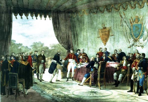 click for larger image | Traité avec les Etats Unis [Treaty with the United States] F. Adam, delineator [Metts?] lithographer Late nineteenth century |
| This is a highly romanticized depiction of Napoleon signing the Louisiana Purchase. Experts agree that on May 18, 1803, the day Napoleon signed the documents, he was much more concerned with an impending war with Britain, a slave uprising in Haiti, the large sum of money about to be added to the French treasury, and other pressing matters of state. The French held no elaborate ceremony, and it is very unlikely that more than three or four people were in attendance. Napoleon's Minister of Foreign Relations Charles Maurice de Talleyrand-Périgord, one of Bonaparte's brothers, and perhaps Marquis François de Barbé-Marbois, the minister of the French treasury who negotiated the deal with Robert Livingston and James Monroe, might have been in the room. The most likely scenario is that the Louisiana Purchase was one among many official papers signed by Napoleon during a routine day's work and that the pomp and circumstance portrayed here were a figment of the artist's imagination. Loaned by Dr. and Mrs. E. Ralph Lupin | |
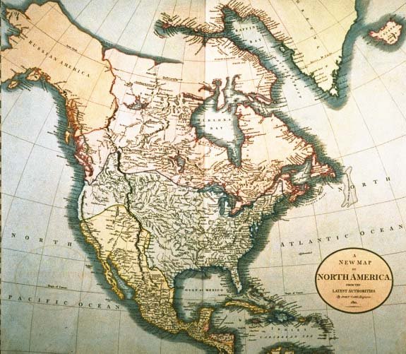 click for larger image | A New Map of North America, from the Latest Authorities John Cary, engraver London, January 1, 1821 |
| This map depicts the Louisiana Purchase boundaries before the northern boundary was fixed at 49 north latitude. Loaned by Dr. and Mrs. E. Ralph Lupin | |
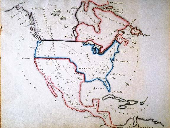 click for larger image | Untitled manuscript map of North America Unidentified mapmaker c. 1850 |
| This map delineates the Louisiana Purchase boundaries after all treaties were negotiated as well an 1846 treaty which settled the boundary between the United States and Canada at the 49th parallel from the Rocky mountains west to the Pacific Ocean. Loaned by Dr. and Mrs. E. Ralph Lupin | |
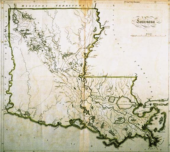 click for larger image | Louisiana M[athew] Carey, publisher Philadelphia, c. 1814 |
| This is one of the first maps published after Louisiana was admitted to the Union in 1812. It shows little detail of the prairies of southwestern Louisiana since they were sparsely populated. Two Indian tribes, the Opelousa (Oppaloussas) and the Attakapa inhabited this area during the eighteenth and early nineteenth centuries. Loaned by Dr. and Mrs. E. Ralph Lupin | |
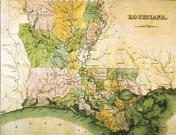 click for larger image | Louisiana G[eorge] W. Boynton, engraver T[homas] G[amaliel] Bradford, publisher Boston, 1838 |
| The names of Louisiana parishes (counties) tell much of the history of the Pelican State. For example, several parishes are named for the Native American tribes living in the vicinity at the time of the European encounter: Natchitoches, Ouachita, and Avoyelles. Other parishes retained names assigned to the area by Indian inhabitants: Catahoula from the Tensas word "cataoola," meaning big, clear lake (Catahoula Lake, now located in La Salle Parish); and Plaquemines from a Mobile Indian and French dialect word for persimmons. Other parish names appearing on this map are French in origin: West and East Baton Rouge (red stick), Lafourche (fork in the Mississippi River), Terre Bonne (good earth), and Pointe Coupee (cut point). The Feliciana (happy land) parishes derive their name from the Spanish language as does Concordia (harmony, unity). At the time this map was published, Louisiana was divided into thirty-two parishes. During the remainder of the nineteenth and into the first decades of the twentieth century additional parishes were sculpted from the large parishes west of the Mississippi River. Loaned by Dr. and Mrs. E. Ralph Lupin | |